Difference between revisions of "National Petroleum Reserve - Alaska"
| Line 18: | Line 18: | ||
|} | |} | ||
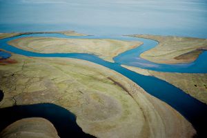
| − | The National Petroleum Reserve-Alaska (Reserve) is the largest single unit of public lands in the nation. Encompassing | + | The National Petroleum Reserve-Alaska (Reserve) is the largest single unit of public lands in the nation. Encompassing over 23 million acres, the Reserve harbors rich and vital wild lands and wildlife, important in their own right and to the Inupiat people of Alaska’s North Slope for their subsistence culture. President Harding established the Naval Petroleum Reserve-Alaska in 1923. Congress transferred management of the area from the Navy to the Interior Department in 1976 and required the Secretary of Interior to provide “maximum protection” for its critical biological and cultural resources. |
In 2013, the Department of the Interior (DOI) adopted a management plan that received strong public support and put in place sensible conservation protections for 11 million acres in the Reserve, setting aside five Special Areas of exceptional wildlife and wilderness value: Teshekpuk Lake, Colville River, Utukok River Uplands, Kasegaluk Lagoon and Peard Bay. DOI spent years working with the tribal community, local governments, the state of Alaska, the Western Arctic Caribou Herd Working Group and the public on the current management plan. The vast majority of commenters supported strong protections for key areas and resources. | In 2013, the Department of the Interior (DOI) adopted a management plan that received strong public support and put in place sensible conservation protections for 11 million acres in the Reserve, setting aside five Special Areas of exceptional wildlife and wilderness value: Teshekpuk Lake, Colville River, Utukok River Uplands, Kasegaluk Lagoon and Peard Bay. DOI spent years working with the tribal community, local governments, the state of Alaska, the Western Arctic Caribou Herd Working Group and the public on the current management plan. The vast majority of commenters supported strong protections for key areas and resources. | ||
Revision as of 08:11, 4 February 2020
| KEY FACTS |
|
The National Petroleum Reserve-Alaska (Reserve) is the largest single unit of public lands in the nation. Encompassing over 23 million acres, the Reserve harbors rich and vital wild lands and wildlife, important in their own right and to the Inupiat people of Alaska’s North Slope for their subsistence culture. President Harding established the Naval Petroleum Reserve-Alaska in 1923. Congress transferred management of the area from the Navy to the Interior Department in 1976 and required the Secretary of Interior to provide “maximum protection” for its critical biological and cultural resources.
In 2013, the Department of the Interior (DOI) adopted a management plan that received strong public support and put in place sensible conservation protections for 11 million acres in the Reserve, setting aside five Special Areas of exceptional wildlife and wilderness value: Teshekpuk Lake, Colville River, Utukok River Uplands, Kasegaluk Lagoon and Peard Bay. DOI spent years working with the tribal community, local governments, the state of Alaska, the Western Arctic Caribou Herd Working Group and the public on the current management plan. The vast majority of commenters supported strong protections for key areas and resources.
Now DOI has started an environmental review process likely seeking to undo protections put in place under the Obama administration in Reserve Special Areas. One of the reasons the Trump administration is moving to open up protected areas in the Reserve is ConocoPhillips interest in more acreage within the Teshekpuk Lake Special Area. ConocoPhillips is doubling down on development in the Reserve, pushing forward with current projects and buying hundreds of thousands of acres for future development, continuing to build upon its growing spider web of oil and gas development projects.
Fact Sheets | Congressional Letters | Maps
Talking Points
- Protecting the NPRA’s special areas, wildlife, and natural values is required by law. The NPRA is federal land with a multi-use mandate, including energy development and conservation. When the Navy transferred the NPRA to the Department of the Interior, Congress wrote a specific law for this land that called protecting wildlife, surface resources, and special areas, including conservation. Congress called out Teshekpuk Lake as a special area worthy of maximum protection.
- Science drove the development of the current land management plan. The 2013 plan represented a big leap forward in our understanding of the science and spatial data, and the area protected under this plan reflects this greater scientific understanding. The public record leading up to the 2013 IAP contains strong justification for recognizing and protecting special areas and wildlife. New scientific understanding has added to the rationale for protecting these areas.
- There is substantial exploration and development across the Arctic and in the NPRA. This development is already causing impacts to fish, wildlife, subsistence, and other values. Re-doing the current management plan now is unnecessary and strains our federal resources in Alaska. We should instead focus on studying the impacts from today’s development, in order to make better informed decisions moving forward.
Fact Sheets
Congressional Letters
- Letter From House Democrats to Secretary Bernhardt Concerning the BLM's Rewrite of the Integrated Activity Plan for the NPR-A, January 2020
- Letter from House Democrats to BLM Deputy Director Steed on Concerns for Special Areas During the Scoping Period of the Notice of Intent to Revise the Integrated Activity Plan for the NPR-A, January 2019
- Letter from the House Natural Resources Committee to Acting Secretary Bernhardt Concerning Public Meetings During the Government Shutdown for the Notice of Intent to Revise the Integrated Activity Plan for the NPR-A, January 2019
Public Letters
- Letter from State Attorney Generals to the BLM Concerning the Rewrite of the Integrated Activity Plan for the NPR-A , January 2020
